Phone: 02 9453 9999 or Email: sales-operations@pcte.com.au

GPR is a technique recording the reflection of electromagnetic energy from within the ground or structure being scanned. A 2D radargram or 3D map that charts these reflections by depth is interpreted to locate or map buried or embedded targets in the material or to determine where layers of material connect.
Ground penetrating radar originated as a geophysical method but is now commonly used for concrete scanning and utility location applications.
GPR post processing software may also be used to extract additional information like deterioration maps of concrete structures, pavement layer diagrams and processed maps that show horizontal or vertical patterns within the data. The software is also able to combined GNSS and Survey information collected by subsurface radar to perform final CAD export of underground utility mapping.
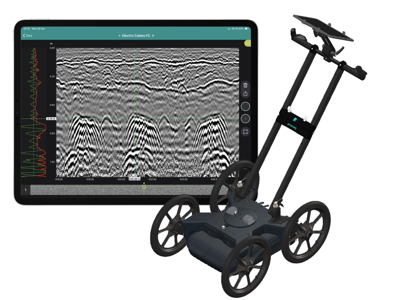
The Proceq Radar that PCTE supply all use Stepped-Frequency Continuous Wave (SFCW) GPR technology, an antenna design which modulates a range of radar frequencies at once. SFCW antenna improve the practical depth penetration and scan resolution near to the surface when comparing similar pulsed GPR antenna configuration.
Metallic targets like reinforcing steel/rebar, post-tension tendons and metallic conduits in concrete or metallic services and shallow cables in the ground return the strongest signal to a Ground penetrating Radar.
Other buried services like plastic conduits in concrete or the ground, ceramic materials and large voids are also a suitable target.
Layers with distinct boundaries such as pavement and subgrade or clear soil layers are also a common locate.
Typical data is presented during data collection or mark and locate work as a 2D slice view / B-Scan of radar reflection intensity at depth.
Grid scans in concrete, or freepath data collection with Proceq's subsurface radar range will be presented either as a heatmap or 3D radar model of the results, allowing for quick interpretation of many scans together.
Subsurface or Utility Location focused radar will penetrate concrete pavements or roadways, with the SFCW of Proceq's GS8000 providing particularly clear imaging of embedded reinforcing in addition to buried targets beneath the concrete.
Heavily reinforced concrete will reduce or eliminate radar energy, so some loss of performance is possible.
Dedicated concrete scanning radar will typically penetrate up to a maximum 500-700 mm of concrete, and if the concrete is thin the radar energy will allow the operator to view signals reflected from targets close to the concrete in the subgrade, but concrete GPR is not an appropriate tool for even shallow utility location.
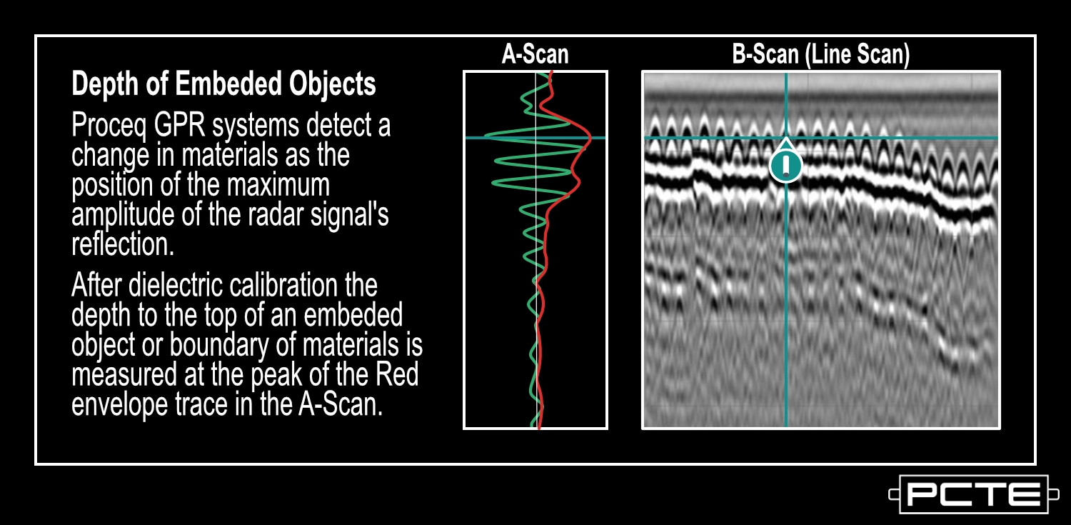
For Proceq GPR units the boundary between materials is detected by the peak signal of the radar detection. Users may locate this position by using the A-Scan view and measuring or placing their marker in line with the maximum of the Envelope response for the desired target.
The ability of GPR to locate a buried target is controlled both by the material of the target and a ratio of its buried depth vs diameter. It is also possible to locate the signal from soil disturbances from trenching when PVC targets are direct buried.
To locate a buried target it should be no deeper than a depth:target diameter ratio of 24:1. for example a 2 cm PVC pipe could be directly located to a maximum depth of 48 cm, a little less than half a meter.
PVC or other non-metallic targets also produce a weaker signal, so operators must be carful to look for apparently weaker targets when PVC is expected.
%20vector%20logo.svg)